I am sitting in a cafe at Wilpena Pound Resort writing down these thoughts. The race was cancelled yesterday under the inclement weather clause. Without such an interruption and under expected conditions, I would have been nowhere near this comfortable place. I would have arrived at Quorn or be making my way towards the finish line of this inaugural Irrational SOUTH at the Flinders Ranges.
This has been an eventful race. There have been Chinese whispers floating around; many I found to be inaccurate. Here is my version of what transpired, from my direct experience. I do not represent any other runner in expressing these views.
First of all, thanks to organisers and volunteers of this event, I had the opportunity to find myself in this beautiful region again. I had been looking forward to this event for some time. The Flinders Ranges is rich in history and, for an adventurous spirit like myself, presents a wonderful playground for a couple of days. I went into this race in high spirits and figured my number one risk would be nutrition. Would there be food at aid stations apart from chips and lollies? There was always a risk with nutrition when you run unsupported on a new course for the first time. You just never knew what would be available. I had taken care to put food in drop bags, but really, when you run over 4 days, no amount of packaged food can replace the real food that the body desperately needs. Boy oh boy, my risk assessment was way off the mark!
The race started at the aboriginal Wadna shop with the shop owner Christian’s smoke cleansing ceremony. It was a cold morning, but soon the sun broke and we were off on our way. The first couple of segments totalling a marathon was run on dirt and paved roads. It was a bit dusty now and then when cars zoomed by, but overall uneventful. I paced myself well as usual, saving up a time buffer for the later stages of the race. Arriving at the first aid station Glass Gorge, the first thing I looked out for was food. There were lollies, chips and fruits. I recall there was another sweet option too, but I do not have a sweet tooth, and do not consume much sugary stuff when I run. I helped myself to fruits, and started working on a Plan B. What if the next aid stations would serve nothing but lollies, chips and sweet stuff?!
The second aid station Parachilna Gorge offered a vegemite sandwich. Much better, I thought, and was thankful for it. But very soon, I was going to need some real food. Fortunately, the following aid stations always had some food on offer, not the standard of the last Delirious WEST or Tahoe or Tor des Géants, but at least something not sugary that I could take. But my real risk, totally without prior warnings, was starting to emerge.
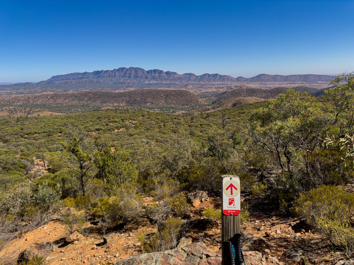
When we started going off road and onto the Heysen Trail, it was not long before I realised that in many parts of these national parks, there were no trails, or, if there were, the overgrown bushes would tend to blur the trail lines. So I was at the mercy of the Heysen Trail markers. This was where the real fun began. The markers here are something else. They seemed inconsistent, infrequent and at times even inaccurate. So I started combining these markers with the GPX file on my watch and on the Gaia app for cross checking. When I entered segments without the markers, I relied on the digital map. Very soon, the map took me around in circles into areas where no track could be spotted. I ran into a couple of runners who had similar issues and they seemed to be wandering around in circles too. It was a tricky situation, because following the map meant you were constantly bushbashing up and down hills through overgrown bushes and spiky trees. Not fun, you can tell. I needed to be very careful to avoid those spiky branches from poking into my eyes. This went on for many hours until I could spot another Heysen marker, about 300m away on the top of another hill, beyond a barbed wire fence! That was when I realised that the map was definitely wrong.
Time for Plan B, I thought. If you could not trust the map, then the only strategy forward was to rely on the Heysen markers. When you found a marker that says “go straight”, usually it worked out. But there were times when you’d keep following a straight track ahead for a few kilometres and then suddenly see another marker on another trail 50-100m away. Very confusing. I hope some day someone could explain the logic behind this marking system for me. I claim to be no expert navigator. However, I have run on all seven continents over many ultra races and never encountered such a confusing system. But the markers that posed the real challenges were the ones that pointed slightly left or right. In other national parks, when you encounter a fork, then you would expect to find another marker right ahead which marks the entry to the next segment. On the Heysen, sometimes you find these next markers. Half of the times, you don’t! So “slightly left” could mean 10°, 30°, 45° or 60° to the left. As you would in these circumstances, the natural thing to do was to read the landscape and look for shoe marks to guide you. In about 80% of instances, that strategy worked out. But in the remaining 20%, I found myself really out of my depth as a navigator. In these cases, I had to pick a certain direction that looked most likely and ran ahead to spot the next marker. As the markers were infrequent, running ahead could mean bushbashing up a hill for 500m, even 1-2km to find nothing, then retreating to the previous known spot with a marker, picking another direction and repeating. There were many turns on the trail, so this scenario was occurring at an alarming rate to a point where it seemed like for every kilometre I managed to run on the correct course, I had to spend half of that distance just to find the likely route. Needless to say, it was exhausting mentally and physically. But ultra runners do not typically complain about these things. We put our heads down and continue to solve problems. Hours passed with increasing mental fatigue in constantly looking for markers and shoe tracks and second guessing the digital map. The sun eventually started to set, and the long hours pushing through the night with George from Bunyeroo were straightforward. For me, those 25kms to Wilpena were a welcome relief from navigational concerns, but boredom started to sink in with an increasing desire to lie down for a rest. George wanted to have a dirt nap, but I pulled out the “whip” and urged him on.
I arrived at the first sleep station at Wilpena Pound and decided to have my first one-hour nap. I could not sleep anyway, probably due to high adrenalin level, but it was good to lie down for a while. It was wonderful to see my family who came out to see me in the wee hours of the morning. Then I started out with Ian to do the loop up St Mary’s Peak saddle. I had been looking forward to this climb after exploring around Wilpena a few days before. The climb followed the outer track, which means you climb up the little mountain on the outer rock surface, facing the rising sun. The sharpest rise was about 300m over 2km according to my watch, mostly involving rock scrambling. It was certainly challenging but I did not mind it. I would not have tried this route, though, if the rocks were wet. It would be far too dangerous. I am not a mountain climber, and these technical routes are always tricky and require the climber to be at their sharpest. One slip of the foot on narrow rock ledges and you would probably fall to meet your Maker.
Finally I made it to the saddle. There were still 1.6kms to reach the summit, but it was forbidden ground, considered sacred by the Aboriginal people. So the route started taking me downhill following the inner route. It was very rocky and probably even more challenging for me than the up. This 18km loop back to Wilpena took me more than 4 hours to complete. But I still left Wilpena with a healthy 6 hours ahead of cutoff. I said goodbye to my family and did not expect to see them again until the finish line in Quorn.
It was close to noon when I left Wilpena to head toward Blacks Gap. The temperature was in the mid twenties, but it was stinking hot out here in the Outback. It had been hot on the dusty roads on the first day. It was even hotter now in the full exposure to the sun with no shades for relief. The first 7-8kms were flat and easy to navigate. The Heysen was up to old tricks again with its markers, and the digital map in and out of accuracy, but by this time I had learnt a few things about these beasts and had their measures. I had realised by then that the markers and the map were not my friends. They were parts of the challenges of this course. Between aid stations, I was my only friend! Then a rocky ascent to Bridle Gap revealed more minor errors in the digital map, but I found myself “reading” these errors a bit better. It was a challenging segment for me in the rising heat, but it was nothing compared to the upcoming leg from Bridle to Blacks Gap. After winding up and down the rocks for a while, I encountered a slight turn-left marker. I could not find the next marker after scouting the area for a long time. The view of the mountains from this elevation was majestic, very striking, and my heart was full of Vitamin Nature. But my heart was also starting to send me warning signals.
With no markers in sight, the only option was to trust the map and trust the work that the organisers had done. I found myself descending this very high dodgy looking ledge and wondered how I would get back up again if the route turned out to be wrong. Well, it was not long before I found myself surrounded by big slippery boulders and spiky things of different kinds. I continued to scout for options, as the map was clearly wrong, but there were no visible paths down this very steep face of the hill. I bushbashed and bushbashed. There was no phone signal. Plan B was gone. Time for Plan C then Plan D… Then I heard voices. Another runner must have heard me rustling the bushes or mumbling to myself. It was my first encounter with Debra, an Adelaide runner. She was lost too. The two of us then joined forces to find a way forward. Debra proposed to descend anyway picking a random path. I studied that route and could not look beyond a rocky turn. What if you got down to that point and found a dead end? It would be very difficult to get back up again. Also that route down looked very treacherous and you could easily find yourself slipping and sliding down. This was an adventure alright, but hey, in the larger context, it was only a fun run. I thought it would be silly to take such risks when your life was not dependent on it. I proposed to go back to the last found marker and wait there until another runner came along. Perhaps other runners would know things we did not. And that was what we did. Debra and I scouted different directions for the next marker, until I heard voices. Luck was on our side. It was a walker with his son hiking up from the other way. I asked him for help, and he took us to the point of the next marker. Being so well hidden, it was no surprise that both Debra and I had not been able to find it after such a long time scouting the area. The descent from here was very steep, but straightforward navigationally. It was during this descent that I started to ponder the possibility of a DNF. I was feeling fine physically and mentally, also well ahead of cutoff. But the reality was that I could no longer trust the map. And if taking a wrong route meant I had to deal with life-threatening risks, then I would be filled with regrets and a sense of irresponsibility toward my family. Mind you, if you read this, I am not exaggerating the situation at all. But contextually, I am likely a “soft runner” amongst ultra-runners. There are many more resilient and tougher runners out there who probably would find this nothing at all and be willing to take such risks to finish a race. I would not, and will never accept risks beyond a certain level. I do not run to prove any point to myself or to anyone. I run for fun, joy, a bit of Vitamin Nature, spiritual growth and health benefits. With that expectation comes a certain degree of risk that I would accept.
At the Blacks Gap aid station, I pondered my next decision point. I was facing about a 32km long haul to the next sleep station at Mt Little. I made a commitment that if navigation of this leg was straightforward, then I would continue on from Mt Little. Otherwise, regardless of my condition, I would end my race there.
This leg turned out to be the most challenging navigation of the entire race so far. For most of this part, I was with Debra and my old running mate Darlene. If there had been a simple instruction before the race “Just follow the creek bed in this segment”, then a lot of the unnecessary navigational doubts and uncertainties would have been avoided. The map was wrong in many parts, and countless hours were lost trying to find the route forward. At times, I thought it might be impossible to make our way out of this bottomless pit. There was no phone signal in this part, like on most parts of the Irrational course, so with the long cold night ahead of us with no shelters, how were we going to get help if we found ourselves in trouble?
It was a long night with the three of us fending off sleep demons, walking for something like 10-11 hours since the last aid station, mostly on rocks, navigating, doubting, retreating, proceeding, hoping, losing hope, hoping again. About 3 kilometres away from Mt Little, I made up my mind to DNF. There was a one-bar phone signal here, so I called Jane at around 1am to ask her to drive to Mt Little and pick me up. Jane is not adventurous, and I knew her driving out at midnight dodging wild life on the road would be a personal challenge. Nevertheless, I weighed up my options, and figured she would not have liked it if I chose not to call. So I called, and hoped for the best.
When we started to run out of options looking for a path out of the creek bed, with the map being useless here, luck found us again. Another runner came back the other way, and she pointed us to pink flags that would lead us to the sleep station. This was the second area of the course where you would find pink flags. The first area was at Wilpena. There were no pink flags from the race anywhere else on this route, even where there were no markers and the map was wrong. At those locations, you were entirely at the mercy of your intuition and luck. In hindsight, the Bibbulmun track that the Delirious WEST 200 miler follows does a wonderful job with its snake markers. Do not expect anything remotely like that scientific system here on the Heysen. I think if you are a hiker out an a casual stroll, you can have a bit of fun playing hide-and-seek with these markers, but if you are a runner on an event trying to beat fatigue and cutoff times, this marker system could be a safety hazard.
When I made up my mind to DNF, I did not say anything to Debra and Darlene. They were running their own races, and even though my decision was entirely rational, it might come across as being negative and demotivate them. We entered Mt Little, Darlene and Debra quickly finding their rest with their crew. I quietly said to the aid station people that I would DNF. Raqs, who had been generously supportive at a number of aid stations, was there. I owed it to her the reason of my DNF. So I pulled her to a quiet corner and explained my reason. I was at the aid station for about 15 minutes, had a cup of tea, before Jane arrived. I felt joy again after having made the decision, and realised for the first time how it felt like to be joyless in a race like this. I had done close to 180kms, including the extra miles of getting lost, in this race and enjoyed many beautiful sights of the Flinders. But when the risks were beyond my accepted level, I had no option but to call it quits. Pushing on seemed irrational! If such a dark joke was by design, I would not have any bar of it.
As it turned out, most runners could only proceed for another 40kms or so before the weather turned for the worse leading to the cancellation of the race. Anyone still moving was considered a finisher of the race under the inclement weather clause. I did not finish the race. But I had more respect for myself for having made that tough call to DNF, especially when I was still fine physically and mentally with 7 hours ahead of cutoff. I considered that a responsible decision. A hearty congratulation to all runners who attempted the race. I figure everyone fortunate to have escaped major injury in this race, but that is my view and my view alone.
So that was my Irrational adventure. I did have some fun, but the fun was not worth the risks I had not been aware of and was asked to take only while I was already on the course. If I had known the digital map was in parts inaccurate and that the Heysen markers were unreliable, I would have brought paper maps. This is one of the courses where organisers should have made paper maps mandatory. We all have a certain level of skills and acceptable risks, and thus my experience is personal, of course. It does not represent any other runner’s perspective of the race or the course. I will now give the planned Unreasonable EAST 200 miler in August the wide berth, and focus energy on re-attempting the Tor des Géants 330km in September. With the TOR, at least I know what risks I am facing. My Triple Crown campaign is over, and I am good with that decision.